ASU student aspires to use passion for data, geoscience tools to support public lands
School of Geographical Sciences and Urban Planning senior Margaret Tueller participated in the National Park Service’s highly competitive “Geoscientists in the Parks” program.
Margaret Tueller is a visual learner with a curious mind. With an affinity for analytical problem solving and spatial thinking, she found a home in studying geographic information systems (GIS) and urban planning.
“When I was deciding what major I wanted to go into initially, I was interested in astrophysics because I love science and math, but I wanted something where I could visualize the results in a more practical timeline than astrophysics might do,” Tueller recalled.
“That's when I decided urban planning would be the perfect choice. Then when I learned about GIS through the urban planning program, I realized it had those key elements of math and statistics that I felt I was initially missing to have a rounded education with spatial and practical projects that I could work on.”
Tueller, who is a senior in Arizona State University's School of Geographical Sciences and Urban Planning and is double majoring in geographic information science and urban planning, aspires to use her passion for data and geoscience tools to support land management and conservation, like that of the National Park Service.
“One thing that's important to me is that since these are public lands, they are available to everyone,” Tueller said. “It's interesting to consider: How can we get as many people to the parks as possible? How can we plan for folks who maybe aren't as outdoorsy, who maybe don't want to go backpacking for eight days? What resources are available to them? And how can we advertise the parts to them so everyone can enjoy these resources?”
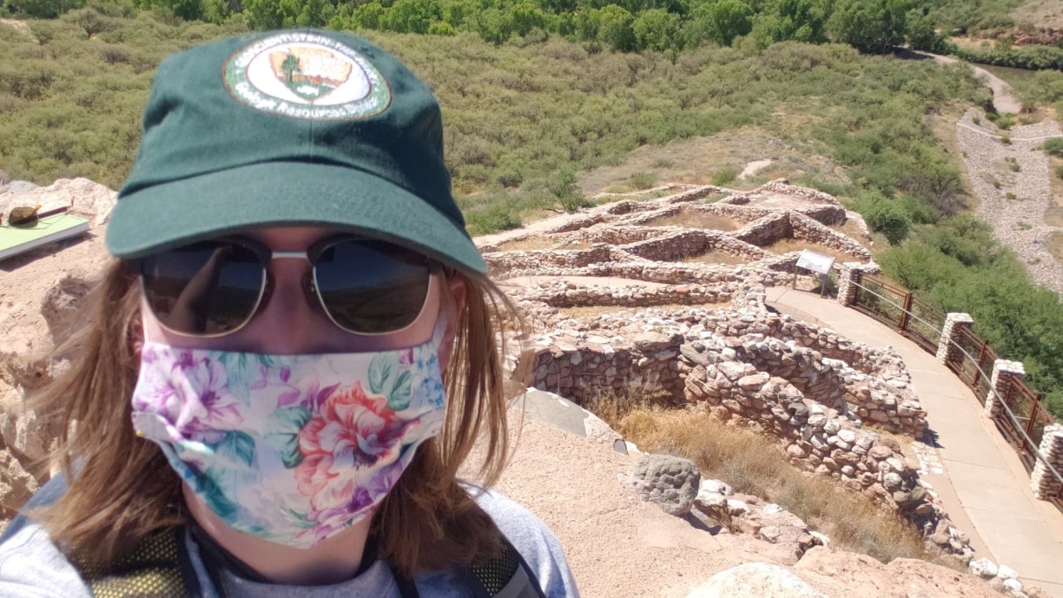
This past summer, Tueller, who is also a Barrett, The Honors College student, participated in the National Park Service’s highly competitive “Geoscientists in the Parks” program. During her internship she used geospatial data to help inform current and future park zoning, which is key to managing different aspects of the park including visitor use and resource allocation.
“GIS can be used to easily communicate a vision for a park system,” Tueller said. “You could make a map or show zoning options that can help visualize and manage desired conditions. GIS can also be used in a more traditional science sense through partnerships that study geology, history or reconstruction maps; GIS can apply to all of it.”
Across the School of Geographical Sciences and Urban Planning, Tueller’s commitment and passion is evident through her studies and work ethic.
“Margaret is a committed and passionate student with a focus on tomorrow and professional preparedness,” said Steven Maierson, academic success specialist in the school. “Students like her are positive beacons and role models that other students should aspire to when navigating a degree program. Being a self-starter, getting involved and researching opportunities are all stand-out student markers that Margaret embodies.”
We spoke with Tueller and asked her a few questions about herself and her internship with the National Park Service.
Question: How did the COVID-19 pandemic affect your internship experience with the National Park Service?
Answer: I did everything remotely. I had an opportunity where I went up to Tuzigoot National Monument and did some work with the NPS cultural resources team that came down from Denver and got to meet a couple of people for the day with masks, on which is fun, but otherwise, I attended meetings, submitted all of my work online and presented online.
I tried to replicate experiences and social interactions I would have gotten at an office on a digital platform. It was a real challenge, but lots of people were willing to meet with me over lunch with a video call and just listen to my questions or tell me about their day. I tried to form as many connections as I could despite the circumstances, and everyone was willing to do that with me.
Q: Which professor has taught you the most important lesson at ASU so far?
A: The most important thing I’ve learned is the importance of working with people. I’ve had Dr. Jason Kelley for a lot of my classes, and at the end of the day, he never lets us forget that urban planning is all about working with and for people, which is important to know and understand. A scenario may be perfect on paper, but it’s all about the people you’re working with to get something done or who will ultimately approve what you do.
Q: What's one interesting fact about yourself that only your friends know?
A: I really enjoy making art and drawing and painting. I really like to draw and have been getting into watercolor a lot more recently. It kind of feels like an obvious one for me when I'm not working on school.
Q: If someone gave you $40 million to solve one problem on our planet, what would you tackle?
A: I would invest it into new energy solutions. I would definitely invest it in advancing renewable energy technology so that we could find other solutions and start those as soon as possible to reverse the effects of climate change.
More Environment and sustainability

Celebrating Earth Day around the world
Originating in the United States in 1970, Earth Day is now celebrated worldwide. But even before it became an official day, many…

A run on fossil fuels: ASU professor says climate legislation could have unintended consequences
As concerns about climate change grow, policymakers are increasingly voicing support for stricter fossil fuel legislation. Their…
Confusion complicates US recycling efforts
In most major cities and buildings, recycling bins can often be found alongside trash bins in an effort to encourage recycling.…