Predicting the flood before the waters rise
ASU engineers work on warning system for urban flooding using traffic cameras

It’s the night of Sept. 8, 2014. Over metropolitan Phoenix, a summer monsoon collides with a dying Pacific hurricane. Rain gushes from the skies. Freeway pumps on Interstate 10 fail. Early morning commuters abandon their cars, which simply float away. Interstate 17 and U.S. 60 in Mesa also flood because pumps can’t cope with the deluge. City officials close dozens of streets. The mayor of Mesa calls the flooding a “slow-moving disaster.” The governor declares a statewide emergency.
That storm has gone down as the most destructive in Arizona history. Nationwide, urban flooding is becoming more intense. This summer saw similar storms hit New York City, Washington, D.C., and New Orleans.
A team of researchers led by Arizona State University faculty is working on a way to warn people about urban flooding.
Called Flood Aware, the idea is to use traffic cameras as eyes on intersections, measuring the observations. That data will feed into models with existing and predicted rainfall and then forecast (or report) flooding.
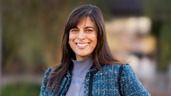
“Here are the areas that are likely to be flooded in the next hour, based on this forecast and where we already see flooding,” said Margaret Garcia, describing an example result of the system.
Garcia, an assistant professor in the School of Sustainable Engineering and the Built Environment, researches the sustainability and resilience of urban water supply systems. She is co-leading development of the three-year project, which kicks off this monsoon.
Water gauges are placed at rivers and streams everywhere by various government agencies. If you ski, kayak or raft, you’re probably familiar with them in predicting how fun a weekend you’re going to have. But they’re absent from urban areas because flooding is different in cities.
“What’s missing is data at the human scale of flooding, particularly in urban areas,” Garcia said. “The flooding mechanism is different.”
Riverine flooding typically affects larger areas. A single gauge can tell you what’s going to happen in a large area up and downstream of the gauge. Urban flooding is typically caused by intense rainfall which generates more runoff then the stormwater drainage system can handle. It tends to be small and localized: an intersection here and there, for instance.
Garcia described the group’s solution: “We want to try to utilize a group of cheap/existing technologies that we could either build upon in a small way or make use of what’s already happening in order to get distributed information, because that’s what’s really important in the urban environment is that we need measurements in a number of different locations in order to make sense of what’s happening and to get useful information to people about areas they might want to avoid.”
The porject will use traffic cameras — ones pointed at curbs and gutters rather than cars passing by — to observe the intersections, and then use image processing algorithms to estimate the depth of the water. Estimating the depth of the water and combining it with hydraulic models of storm water systems will give information about nearby areas.
“The idea is we could take these observations, integrate that data into our existing model along with either observed or forecast rainfall data, so we can then run our model multiple times — rainfall has just happened — feed in those data points where flooding is observed, and then make a probabilistic projection of where flooding is likely to be already occurring besides those points where we don’t have cameras and then we can also do that in forecast mode,” Garcia said. “Now is our first field season to put some of these ideas into action.”
They will install five cameras in Phoenix. The plan is to start with a high-end camera and strip away capabilities until they find out what’s really required. They’re also not using city equipment while the technology is being developed. “It’s definitely in the trial and error phase,” Garcia said.
Eventually the system could be linked to an app that would work the same way traffic apps work now.
ASU engineering professors Mikhail Chester and Giuseppe Mascaro are also working on the project.
Top photo courtesy of Getty Images/iStockphoto.
More Science and technology
ASU planetary scientist to be inducted into the National Academy of Sciences
The National Academy of Sciences is inducting School of Earth and Space Exploration Director Meenakshi Wadhwa into the 2023 class of new members for her pioneering work in planetary sciences and…
Unlocking the potential of AI for homeland security
“Can we do what we're doing now cheaper, more efficiently, more effectively?” Adam Cox, director in the Office of Strategy and Policy at the Department of Homeland Security Science and Technology…
SpaceHACK highlights student solutions to environmental challenges, digital divide
By Adrianna Nine About 250 students from around the world convened online and at Arizona State University on March 22 for the ASU Interplanetary Initiative’s second annual SpaceHACK for…