Google, Uber make ASU a hot spot for mapping technology
In separate projects, tech firms acquire images, data that have a range of possible uses in fitness, business, civic planning

Arizona State University has been more of a tech hub than ever, with tricked-out cars cruising under the Tempe campus' University Bridge while young men nearby lug gadget-heavy backpacks past Old Main.
In separate projects, Uber and Google have been mapping a school that has become known for jet packs, robot swarms and NASA missions.
Uber’s work involves self-driving cars with sensors and gadgets on the roof of a small SUV that otherwise don’t give any indication of what makes them unique on Tempe roads. The cars have a human behind the wheel.
Google, meanwhile, is expanding its Street View feature, capturing close-up images of all of ASU’s campuses. The feature on Google Earth and Google Maps allows users to zoom in and see accurate depictions of buildings and sidewalks, anything a pedestrian could see walking down the street.
Each relies on mapping technology that seems poised to expand.
“It is quite an amazing system,” said Stewart Fotheringham, a professor of computational spatial science in the School of Geographical Sciences and Urban Planning. Fotheringham teaches a class called Geographic Info Technologies (GIS 205), which introduces students to modern geographic information technologies, including cartography, GIS, remote sensing, global positioning systems and statistical analyses.
He explained how the technology works.
“The video recorders Google people carry around with them record 360 degrees and are linked to the U.S. GPS satellite system, which consists of 24 active satellites about 12,000 miles above the Earth,” Fotheringham said. “Distances to four or more of these satellites give location on the Earth, plus elevation, so when you type an address into Google Earth, it looks up the coordinates of this location in a huge database and retrieves the imagery associated with this location.”
The imagery consists of satellite photographs and pictures taken from planes for Google Earth. Video recordings are taken by people on foot or bike and by cameras mounted to cars for Google Street View.
Andrew Ortiz is one of the field operators who troops around under the weight of a nearly 70-pound pack to get the shots the technology relies on. He and Daniel Quach took turns under the Google Street View Trekkers, a backpack outfitted with a camera system that’s used where vehicles can’t go.
It can be a tough task. “Our tolerance has been building,” he said. “I could probably walk about 2½ miles (before taking a break.)”
Google’s field operators worked around Tempe campus on March 6, starting in the middle of an area and walking out in concentric circles snapping pics with about a dozen cameras on a ball array at the top of their packs. In a mile the array will take about 500 to 600 shots, according to Ortiz.
Before coming to ASU, Google personnel worked with the university to come up with a priority list. They will shoot interiors in certain buildings, like ASU Gammage, but not every building on campus.
Uber cars have rolled past the Frank Lloyd Wright-designed Gammage and ASU’s School of Music, affectionately known as the “birthday cake building,” and the Ira A. Fulton Schools of Engineering countless times since their program introducing the vehicles to the Valley began in February.
Driverless cars need far more detailed digital maps than cameras and radar alone can provide, and Uber is recording every curb, stop sign and building to ensure their system works effectively. The cars include a pair of engineers in the front seats as safety drivers, according to a report in the tech-focused publication The Verge.
Arizona Gov. Doug Ducey has hailed Uber’s self-driving pilot, releasing a statement saying his state’s participation “is paving the way for new technology and new businesses.”
The emerging mapping technology has a range of uses and applications.
“It's used by Realtors and house buyers, in in-car navigation systems, and by planners,” Fotheringham said.
Google, for example, takes a constellation of images that anyone could access from GPS satellites, then applies 360 camera technology and manages the the logistics of capturing video imagery on every road and street it can access, Fotheringham said.
-
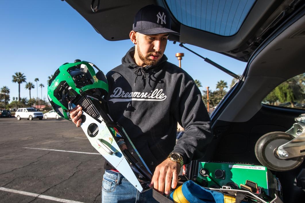
Google Maps Street View walker Andrew Ortiz, from San Jose, assembles and boots up the Trekker. The process takes about 10 minutes.
Photo by Charlie Leight/ASU Now
-
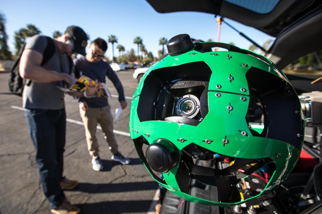
ASU's Brandon Mart (left) discusses a logical walking route with Google Maps Street View walker Daniel Quach in the ASU Gammage parking lot while the nearly 70-pound pack boots up and connects to the satellites.
Photo by Charlie Leight/ASU Now
-
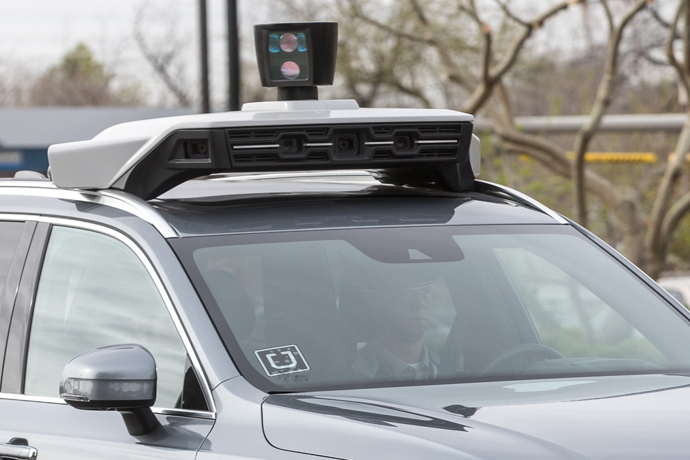
A self-driving Uber SUV travels north on Mill Avenue as its cameras take images of each curb, building, sign and intersection.
Photo by Charlie Leight/ASU Now
-
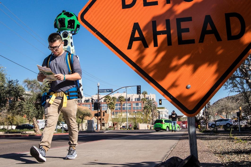
Walker Daniel Quach, of San Jose, treks along the western part of the Tempe campus. He and Google partner Andrew Ortiz switch off the device that marks the location and takes 360-degree pictures as they cover all the streets and sidewalks along the way.
Photo by Charlie Leight/ASU Now
-

Andrew Ortiz strolls through the Mona Plummer Aquatic Complex. He and partner Daniel Quach are creating Google pedestrian maps of all the ASU campuses this week.
Photo by Charlie Leight/ASU Now
-
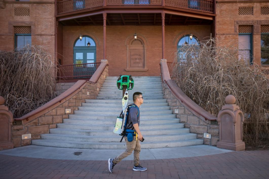
Daniel Quach passes in front of Old Main on the Tempe campus with the Google Street View Trekker taking 360-degree pictures along the way.
Photo by Charlie Leight/ASU Now
-
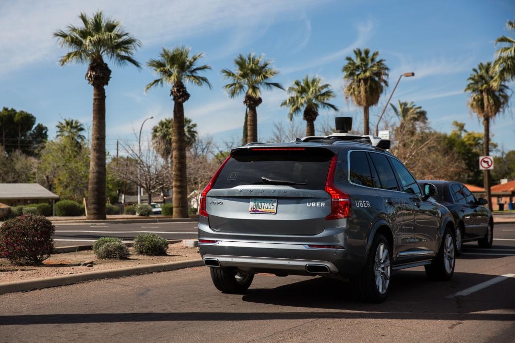
An Uber self-driving vehicle drives down Apache Boulevard in Tempe.
Photo by Deanna Dent/ASU Now
Google’s data sets are turning out to be useful, as well, said Trisalyn Nelson, director of the School of Geographical Sciences and Urban Planning.
“Google Maps was developed originally so people could figure out where to go, and find their roots, and maybe check out an area before they arrive, but because these data sets are wall-to-wall — you have continuous data that maps a whole area with a lot of detail — we’re starting to see new, unintended uses,” Nelson said.
One example is fitness apps. Strava is a website and mobile app used to track athletic activity via GPS. If you’re biking, it tells you how far you rode, how quickly you got there and other similar information.
The people who run Strava realized they had their hands on a huge amount of data on where people were riding bikes. They repackaged it as Strava Metro and now sell the data to cities. More than 70 cities and organizations use Strava Metro to improve bicycle and pedestrian infrastructure.
“Getting data on where people ride their bikes in traditional forms is quite hard, because you have to stand at a corner to count people,” Nelson said. “Now we have this data that’s continuous through time, it’s continuous through space, and we can use it for urban planning to figure out where we should put in bike lanes. So this is a really good example of how new map technology starts off with one purpose — for tracking my fitness — and now we can use it to better understand cycling infrastructure.”
The expansion should be rapid, with tech and auto companies planning to share mapping data and trucking companies installing scanning systems. Next year, Volkswagen, which Uber uses in its self-driving vehicle pilot fleet, and BMW will install front-facing camera systems to detect obstacles. The systems will also passively map and send the data back. With millions of vehicles recording and relaying mapping data, there will be a geometric progression of data acquisition.
Unintended uses of mapping data will continue to balloon, Nelson said.
“We’re excited in our school about it, because on the one hand we do a lot of geographic information science, so we are the people who develop new technology to analyze map data,” she said. “On the other hand, we have all these people who are planning cities — the urban planning community — who are finding huge opportunities to use these new kinds of data sets to better understand what’s happening in a city, to inventory what’s there, to look at how it’s changing over time, to simulate future environments. Having access to these kinds of data opens up a lot of potential.”
It’s also opening up a new career field. A recent Forbes list of the top 10 growing jobs included two that fell in the category of working with maps and another technology. Computer science, statistics and geography are all taught at the School of Geographical Sciences and Urban Planning.
“We’ve seen this huge explosion in jobs for people who can work with maps, because maps are no longer something you draw,” Nelson said. “There are a lot of jobs associated with digital mapping technologies. In order to be really awesome, you need to combine it with something else. … These are very smart areas for ASU students to look for degrees.”
Top photo: As part of Google's mapping project, field operator Daniel Quach treks along the western part of the Tempe campus carrying the nearly 70-pound pack on March 6. He and Andrew Ortiz used the pack to help create pedestrian maps of all the ASU campuses last week. Photo by Charlie Leight/ASU Now
More Science and technology
Making magic happen: Engineering and designing theme parks
The themed entertainment industry is widespread and diverse, encompassing everything from theme parks to aquariums, zoos, water parks, museums and more. The Theme Park Engineering and Design…
AI-equipped feeders allow ASU Online students to study bird behavior remotely
ASU Online students are participating in a research opportunity that's for the birds — literally. Online Bird Buddies is a project that allows students to observe birds remotely, using bird feeders…

National Humanities Center renews partnership with Lincoln Center for responsible AI research
The National Humanities Center has announced that Arizona State University's Lincoln Center for Applied Ethics is one of four organizations to receive funding for the second phase of their…